Search
Katedra Geodezji

Homepage
https://wilis.pg.edu.pl/kg open in new tabAssociated units:
Research fields
Business contact
- Location
- Al. Zwycięstwa 27, 80-219 Gdańsk
- Phone
- +48 58 348 62 62
- biznes@pg.edu.pl
Team
Katarzyna Bobkowska
dr inż.
Paweł Burdziakowski
dr inż.
Mariusz Chmielecki
mgr inż.
Karol Daliga
dr inż.
Mariusz Figurski
prof. dr hab. inż.
Daria Filipiak-Kowszyk
dr inż.
Adam Inglot
dr inż.
Waldemar Kamiński
prof. dr hab. inż.
Karolina Makowska-Jarosik
mgr inż.
Grzegorz Nykiel
dr inż.
Jerzy Pyrchla
dr hab. inż.
Anna Sobieraj-Żłobińska
dr inż.
Andrzej Stateczny
prof. dr hab. inż.
Jakub Szulwic
dr inż.
Paweł Tysiąc
dr inż.
Tadeusz Widerski
dr inż.
Dominika Wróblewska
dr inż. arch.
Paweł Wysocki
dr inż.
Krystyna Michałowska
dr inż.
Marek Zienkiewicz
dr inż.
Emilia Miszewska
mgr inż.INTRODUCTION
Geodesy has always contributed the GUT scientific profile besides the wars and political changes. The present-day geodesy transfers itself enormously. New measuring instruments and new challenges make geodesy not only the art of Earth measurement but the contributor of the following scientific disciplines: „Civil engineering and transportation”, „Sciences on Earth and Environment”, „Social-economic geography and spatial planning economy”. The scientific and research interests of the Department of Geodesy contributing teams address the issues dedicated to geodesy by modern civil engineering, transportation, environmental engineering, mining and power engineering. The research is conducted upon innovative monitoring methods of geophysical structures and engineering objects by means of 3D models, addressing the weather models too. Our Staff works and proceeds the GIS models acquired from aerospace data, unmanned measuring platforms, mobile ocean ships and airplanes. We also focus on a vast domain of gravimetric measurements and its complementary, advanced data analysis, linked with these techniques. Biometrics and expert systems to be employed by state government institutions in crisis events are covered by the Department too. Our strength is assured by a highly specialized staff, renowned both in domestic and European ranges. The details on our experience and conducted research is included in the MOST Wiedzy website. Please, take our words of welcome.
Service offer
- LiDAR surveying and data transformation to the 3D model form
- Spatial analysis on the worked 3D models, including the client’s models
- Weather models of selected regions and time intervals
- Geodetic service upon investments
- Non-invasive material testing incorporating remote sensing methods
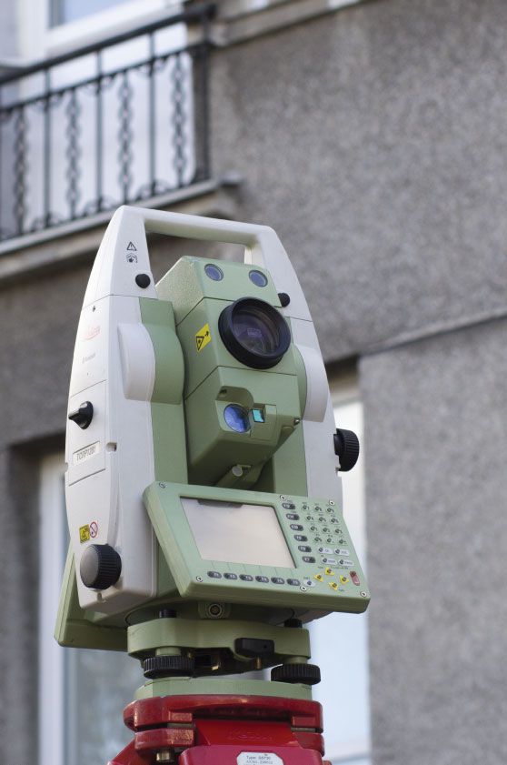
Equipment
- Laser scanners and photogrammetric cameras
- Mobile gravimeter MGS-6
- Satellite positioning system receivers
- Reference station GNSS
- High-precision tachymeters and levellers
Research topics
Oferta badawcza
Oferta usługowa
- Badanie przemieszczeń i odkształceń budowli lądowych, wodnych i urządzeń technicznych oraz elektrowni wiatrowych i wodnych.
- Badania terenowe i modelowe przemieszczeń budowli posadowionych na słabym podłożu.
- Zastosowanie elektronicznych instrumentów pomiarowych w budownictwie.
- Geodezyjne pomiary kontrolne podczas wznoszenia i eksploatacji budowli morskich, kompleksowa obsługa geodezyjna.
- Zastosowanie mapy numerycznej w budownictwie i inżynierii środowiska.
- Pomiary specjalne i monitoring środowiska.
- Pomiary satelitarne, fotogrametryczne i analizy geomatyczne.
Verified by
seen 2925 times