Search

Description
Research data show the church of St. Adalbert in Gdansk, Poland. Two layers are presented in the .zip file: one represents the laser scanning result, the second represents the point cloud from 36 photogrammetry images from the UAV system. The aligned point clouds formed the basis to create the high-resolution 3D model. Reference data are laser scanning data and photogrammetric data form the basis for environment analysis modelling. Moreover, photogrammetry complements the modelling process for information on places that cannot be reached by terrestrial scanning technology. The standard deviation of point cloud alignment is not exceeding 2 cm, however noise filters should be taken into account during modelling and numerical calculations.
Coordinate system: ETRF2000-PL / CS2000/18 - EPSG:2177
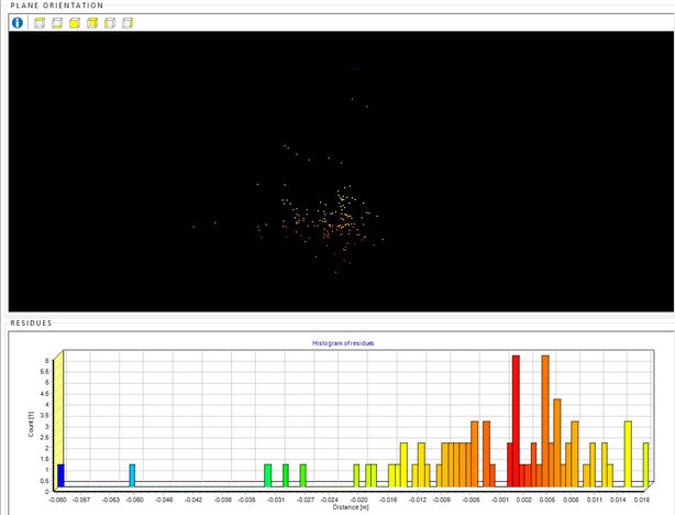
Distance alignment results using Multi- Station Adjustment (MSA).
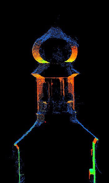
Alignment results of a Tower (Blue- UAV Photogrammetry, Green- RED - Terrestrial Laser Scanning).
Dataset file
hexmd5(md5(part1)+md5(part2)+...)-{parts_count} where a single part of the file is 512 MB in size.Example script for calculation:
https://github.com/antespi/s3md5
File details
- License:
-
 open in new tab
CC BYAttribution
open in new tab
CC BYAttribution - Software:
- Cloud Compare
Details
- Year of publication:
- 2023
- Verification date:
- 2023-01-04
- Creation date:
- 2022
- Dataset language:
- English
- DOI:
- DOI ID 10.34808/6hsv-ds40 open in new tab
- Verified by:
- Gdańsk University of Technology
Keywords
Cite as
Authors
seen 256 times