Search

Description
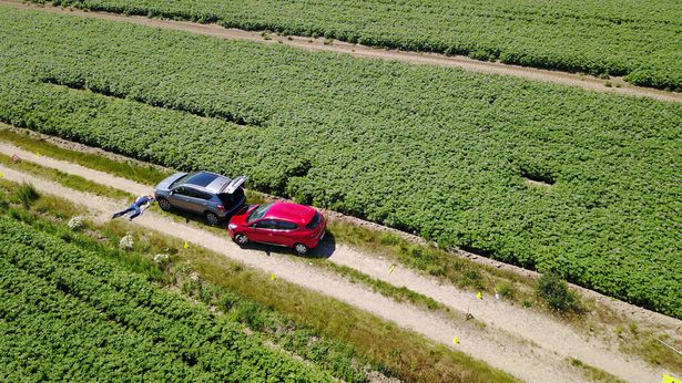
Dataset description: Raw images from photogrammetric and terresttial laser scaning survey.
Object: Simulated Car Accident
Location: Puck Pomorskie, Poland
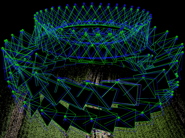
Drone type: DJI Mavic Pro 1
Flight plan: Circle | Point Of Interest
Target Product: 3D Model
Date: 07.07.2017
Direct georeferencing: yes
Metadata data: Yes/GPS
GCP: Yes - some targets on the object are marked and measured by RTK GNSS
Camera Name: DJI FC220
Lasser type: Riegl VZ-400
Model type: Perspective
Image dimensions: 4000x3000 pixels
Sensor size: 6.16 mm
Number of photos: 113
Number of points in Point Cloud: 9 651 673
Example photo

TLS
Camera position
Dataset file
SI Dataset - Simulated Car Crash.zip
524.8 MB,
S3 ETag
12c810185a0b954702599af7c9471513-2,
downloads: 68
The file hash is calculated from the formula
Example script for calculation:
https://github.com/antespi/s3md5
hexmd5(md5(part1)+md5(part2)+...)-{parts_count} where a single part of the file is 512 MB in size.Example script for calculation:
https://github.com/antespi/s3md5
File details
- License:
-
 open in new tab
CC BY-NCNon-commercial
open in new tab
CC BY-NCNon-commercial - Raw data:
- Data contained in dataset was not processed.
Details
- Year of publication:
- 2022
- Verification date:
- 2023-01-02
- Creation date:
- 2017
- Dataset language:
- English
- DOI:
- DOI ID 10.34808/fzs4-wt88 open in new tab
- Series:
- Verified by:
- Gdańsk University of Technology
Keywords
References
Cite as
Authors
seen 135 times