Wyszukiwarka

Opis
The dataset contains data derived from recordings of the AVHRR/3 radiometer operating on board the NOAA POES (Polar Orbiting Environmental Satellites) Series - 5th Generation Satellites covering the Baltic Sea area. The satellite data was recorded in the years 2000-2012 directly by the HRPT station installed at the University of Gdańsk. The registration was carried out in accordance with the criterion that it was made only when the scanning range covered at least 30% of the Baltic Sea area and concerned the last three satellites of the NOAA POES Series. The most up-to-date information about the position of the satellite (TLE) was attached from the website http://www.celestrak.com/NORAD/elements/ during the registration of the signal. But historical TLE data were required from https://www.space-track.org/ www site.
The product level is the NOAA AVHRR Level 1C that is result of processing the AVHRR data from the HRPT stream based on ancillary information like sensing geometry and calibration data. Then converted into geophysical variables: top-of-the atmosphere (TOA) albedo or brightness temperature. Additionally, information like geolocation has been added. Other appended parameters are time codes, quality indicators, solar and satellite angles and telemetry, nadir line, scan area, and other.
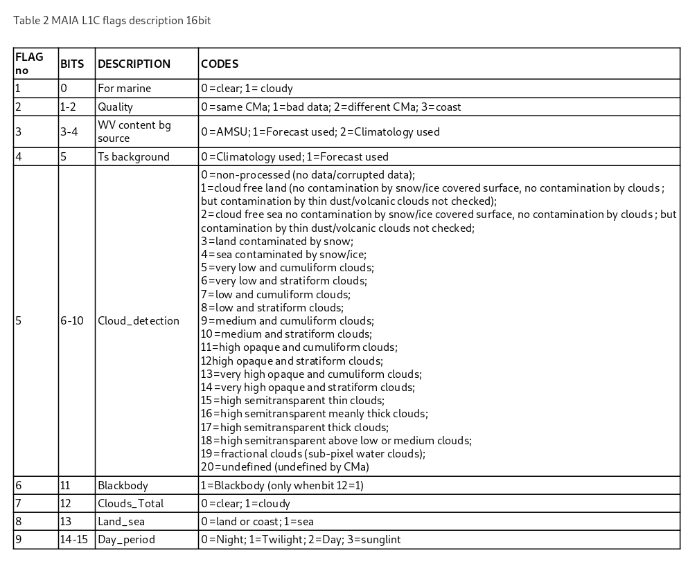
The ATOVS and AVHRR Pre-processing Package (AAPP v7.9) (Labrot et.al. 2011) was used to process raw data registered by the HRPT station of the University of Gdańsk into Level 1C. AAPP is maintained by the EUMETSAT Satellite Application Facility for Numerical Weather Prediction (NWP SAF). The information about the cloud cover in the scanned area shown in Table 1 under number 12 as the mask variable was determined using the MAIA program (Levanant 2002) the type of mask is LEVEL 1C. Geolocation data for each pixel was calculated using TLE data and ASDIK algorithm (Kowalewski & Krężel 2003).
As a result, there are the following variables in the shared dataset.
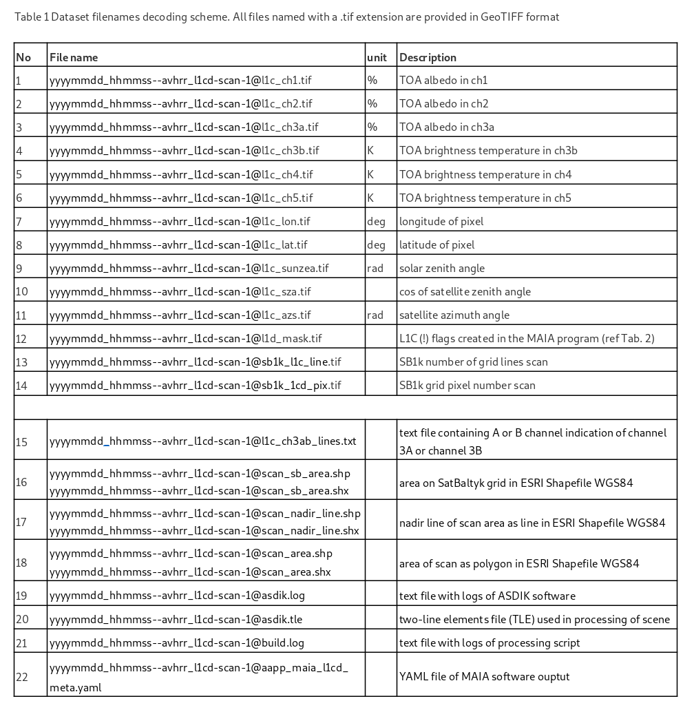
Raster data are provided in GeoTIFF format, in a scan grid using the naming convention:
yyyymmdd_hhmmss--avhrr_l1cd-scan-1@l1xx_var.tif
where:
- yyyymmdd – date of scene data acquisition: year, month, day
- hhmmss – scene center time (UTC): hour, minutes, seconds
- l1xx – level 1 c, d or cd
- var – variable
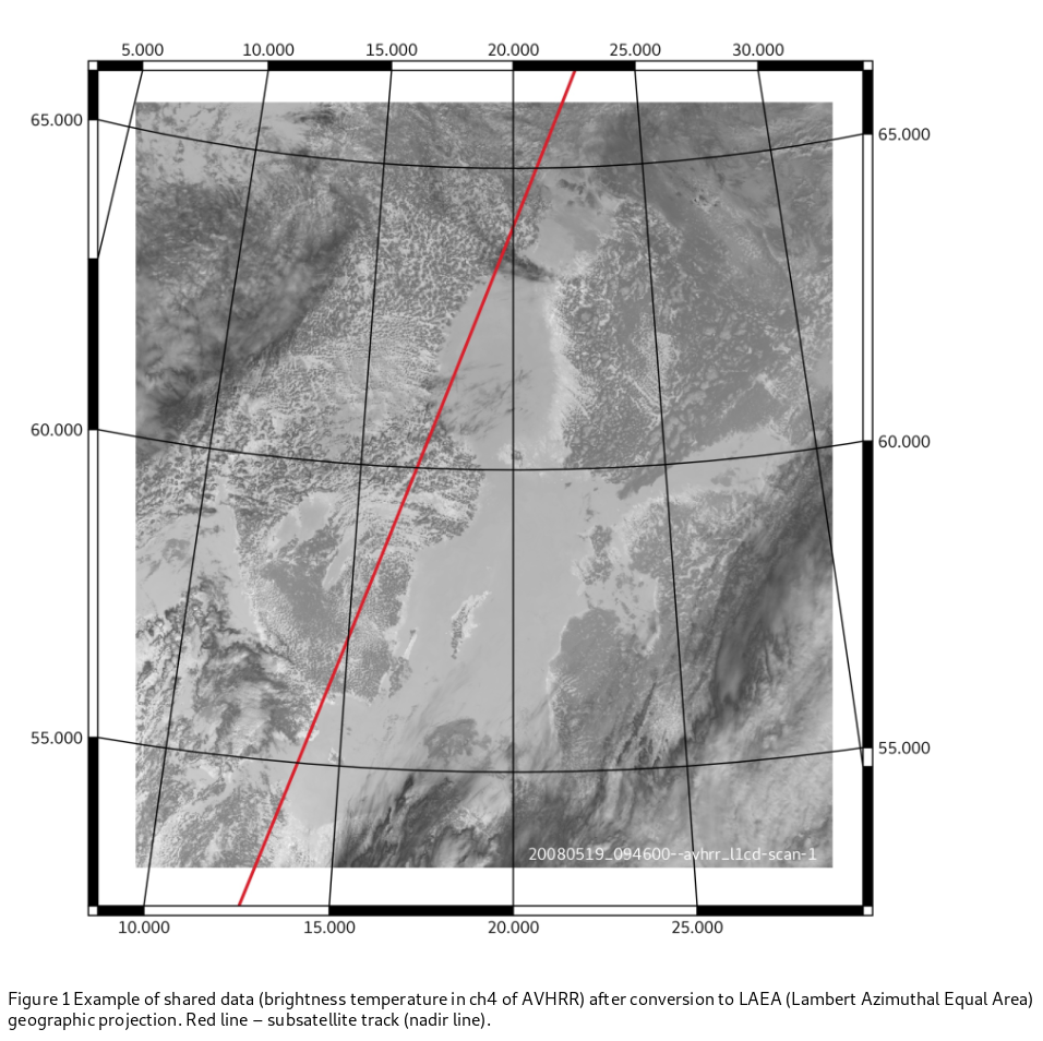
for example (Fig. 1): 20080519_094600—avhrr_l1cd-scan-1@l1c_ch4.tif
DATA SET TIME SERIES SPECIFICATIONS
Spatial coverage: 67°N, 53°N, 8°W, 30°E
Temporal coverage: 2001-01-01 - 2012-12-31
Date of launch: NOAA-12 1991-05-14, NOAA-14 1994-10-30, NOAA-15 1998-05-13, NOAA-16 2000-09-21, NOAA-17 2002-10-15, NOAA-18 2005-05-20, NOAA-19 2009-02-06
Operators: NOAA, University of Gdansk
Mission status: Archive
Orbit height: 804 - 870 km
Orbit type: Sun-synchronous
Swath width: 3000 km
Current Processor Version: 1.0
Resolution: Low Resolution - LR (500 - 1200 m)
Wavelengths: Ch.1 VIS (0.58 - 0.68 µm), Ch.2 NIR (0.725 - 1.0 µm), Ch. 3a SWIR (1.58 – 1.64 µm), Ch. 3b MWIR (355 – 3.93 µm), Ch. 4 TIR (10.3 - 11.3 µm), Ch. 5 TIR (11.5 – 12.5)
Product types: AVHRR_L1cd-scan
Processing level: 1CD
SB1K grid projection (Proj4 library syntax): “+proj=laea +lat_0=52 +lon_0=20 +x_0=4321000 +y_0=3210000 +datum=WGS84 +units=m +no_defs +type=crs”
SB1k grid size (w,h): 1280, 1408
SB1k grid origin (x,y) [m]: (3628000.0, 4776000.0)
SB1k grid cell size (x,y) [m]: (1000.0, -1000.0)
Bibliography
Kowalewski M., Krężel A., 2003, System of Authomatic Registration and Geometric Correction of AVHRR Data (in Polish), Archiwum Fotogrametrii, Kartografii i Teledetekcji, vol. XIIIb, 397-407
Labrot T., Lavanant L., Whyte K., Atkinson N., Brunel P., 2011, AAPP Documentation. Scientific description, NWP SAF Satellite Application Facility for Numerical Weather Prediction Document NWPSAF-MF-UD-001, Version 7.0 October 2011, https://nwpsaf.eu/site/download/documentation/aapp/NWPSAF-MF-UD-001_Science.pdf
Lavanant L., 2002, MAIA AVHRR cloud mask and classification, MAIA v3 scientific and validation document, MeteoFrance, 07/11/2002, Ref: MF/DP/CMS/R&D/MAIA3, 37 s., http://www.meteorologie.eu.org/ici/maia/maia3.pdf
Plik z danymi badawczymi
hexmd5(md5(part1)+md5(part2)+...)-{parts_count} gdzie pojedyncza część pliku jest wielkości 512 MBPrzykładowy skrypt do wyliczenia:
https://github.com/antespi/s3md5
Informacje szczegółowe o pliku
- Licencja:
-
 otwiera się w nowej karcie
CC BY-NCUżycie niekomercyjne
otwiera się w nowej karcie
CC BY-NCUżycie niekomercyjne
Informacje szczegółowe
- Rok publikacji:
- 2021
- Data zatwierdzenia:
- 2021-12-28
- Język danych badawczych:
- angielski
- DOI:
- Identyfikator DOI 10.34808/mgrf-0y64 otwiera się w nowej karcie
- Seria:
- Weryfikacja:
- Politechnika Gdańska
Słowa kluczowe
Powiązane zasoby
Cytuj jako
Autorzy
wyświetlono 186 razy